Green Woods to Fall Brook Gorge
Location
Map Legend
Icons on the map can be clicked to get directions on Google Maps (works best for Parking Icons).
Get the Map
This property is in NQTA Map #16. You can purchase NQTA Map Sets in our Shop.
Directions
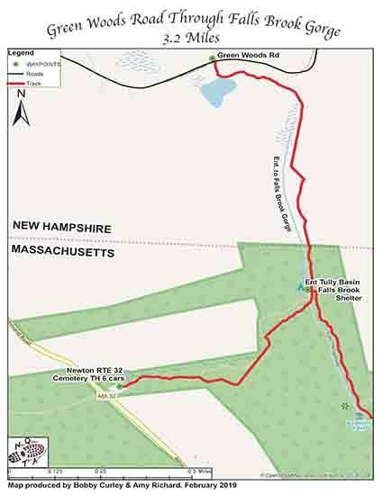
The Rt. 32 Newton Cemetery is located on the right coming from Massachusetts 1.8 MI after the Rt 32/68 split. Take caution as it comes up quickly and is easy to miss.
Parking for 6 to 8 cars.
The parking lot is rather choppy and it can be difficult to place cars correctly so please park as expediently as possible.
Green Woods Road trailhead is located exactly 1.1 MI on the right hand side from the Rt. 32 Newton Cemetery heading north.
Travel down Green Woods road .8 miles and park on a very limited grassy area on left for 2 to 3 cars.
Cross Green Woods Road and start your adventure.
Overview
Starting at the Green Woods Road intersection continue hiking through mixed forest and
begin to enter the geological changes of Falls Brook Gorge.
Take caution in the wet and slippery conditions but be sure to take your time and camera and enjoy the geological wonders of the washbowls and natural stone bridges that have taken millions of years to sculpt. Continue on through the Falls Brook Gorge till you come to footbridge crossing at the New Hampshire / Massachusetts line.
This is the end of the M+M trail in New Hampshire and at this point the Tully trail and NET
continue together as one trail for a couple of miles.
Take trail before crossing footbridge to get to Royalston Falls.
Falls Brook Shelter a large 8 to 12 person shelter is straight ahead and up a knoll.
Continue on the trail following Falls Brook for a third of a mile. Again take caution and be
prepared with a picnic lunch to enjoy the spectacular Royalston Falls.
Follow trail back, cross footbridge and take left on trail and ascend trail back to the Rt. 32
Newton Cemetery TH.


