Longest walk:
6.7 miles
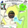
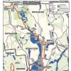
Bear Mountain (2,316 ft.) is the highest peak in Connecticut. It is not, however, the highest point of land in Connecticut. The highest point is 2,380 feet, found on the south slope of Mt. Frissell whose 2,453 ft. summit lies in Massachusetts. Nonetheless, Bear Mountain maintains its distinction as the highest summit in Connecticut and it offers one of the prettiest vistas in the state. It’s a beautiful hike on the Appalachian Trail south of the summit because you’re hiking on rocks, surrounded by low bushes (including blueberries!), and the view progressively opens up for you. A stone pyramid built in 1885, about 8 feet high with a flat top, sits on the summit and provides a great platform for checking out the panorama. Prominently to the north in Massachusetts are Mts. Race (to the right) and Everett (to the left).
Activities: Hiking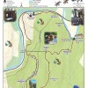
Please be respectful of private property and stay on the marked trail.
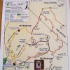
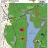
Welcome to Bearsden Conservation Area. Bearsden offers a varied landscape of 5 mountain tops, the Millers River, Deep Cut Gorge, Newton Reservior, Buckmans Brook, Thousand Acre Brook, Duck Pond and beautiful vistas. There are many diverseoptions, from a walk in the forest, horse trails, mountain biking, challenging hikes, and fishing.
Enjoy the beautiful Bearsden, but remember, leave only footsteps (or horse prints), and don’t forget insect repellent, energy foods, and plenty of fluids.
Activities: Hiking, Nature Viewing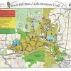
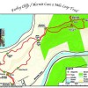
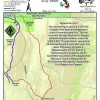
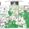
Starting at The Farley Cliffs trailhead to the forest footpath trail by following the white blazes and signage.
Follow trail .3 to waterfall follow the white blazes up the waterfall, crossing brook at top and follow along ridge out and pass Northfield Dam.
Follow this white blaze trail till you come to the blue blaze Hermit Cave trail.
Take a right on to the loop trail out to Hermit Cave and continue on to where it connects and follows up to The Farley Ledges with outstanding vistas. Continue until you are back where the blue blaze loop trail intersection.
Continue on the white blaze trail until crossing of a footbridge and the intersection of the burnt orange trail.
Take the burnt orange trail down to where it intersects with the white blaze again at the waterfall area and continue on to you come out back to the trailhead.
Activities: Hiking
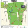
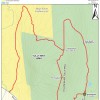
An intro from Ben and Susie Feldman, Landowner. Along the Q-M trail, stop and visit its many resident gnomes. Walk to the Cascades, especially after a heavy rain. Find the Tri-Town Marker and look for old carved dates on it. Go out to Waterman’s Corner, and admire the skills it took to build that stone wall. On the Outer Limit, clamber across the rocks at Celtz’s Crossing. Enjoy the Cutthroat and the Kendall Brooks as they meander through the forest. Occasionally, just stop, breathe, and absorb the peacefulness.
Activities: Hiking
Longest walk:
5 miles

Chapter 6 NET Sections 15 / 16
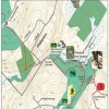
Wendell Forest/ Mormon Hollow/ Farley Cliffs
This corridor of the Q+M Experience is the NET (New England Trail) Sections 15 and 16.
The NET is managed by the Appalachian Mountain Club (AMC) and please respect all protocols and guidelines while on the NET trail section please go to outdoors.org for more information.
Activities: Hiking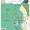
Newton Reservoir/Pipeline Trail- from the Newton Reservoir Gate follows the trail to a ‘Y’ in the road. The left hand side follows the back side of the Reservoir. The right side of the ‘Y’ follows the front of the reservoir. Follow either trail to the Buckman Brook Crossing. The trail then follows the yellow “P” of the Pipeline Trail along the Buckman Brook. Along the way, there are several outstanding vistas providing different view points of this popular water body. Please be respectful of private property and stay on the marked trail.
Activities: Biking, Cross-country skiing, Equestrian, Hiking, Naturalists, Snowshoeing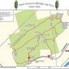
The Poplar Mt. Ridge Upper/ Lower Loop Trail is made up of the main Yellow blazed trail a Lower Loop Trail that traverses the base of Poplar Ridges, offering many geological formations, the Upper White blazed Loop Trail is accessed off on the Western and Eastern side of Lower Loop and traverses the ridge with 4 spectacular vistas.
Activities: Hiking

Area comprises of three trails: Ruggles Pond Trail, Pine Tree Trail and the Civilian Conservation Corps (CCC) Trail. The CCC Trail is a reminder of the men who were given the opportunity to help develop many of the states’ recreation areas during the Great Depression.
Activities: Biking, Cross-country skiing, Equestrian, Hiking, Picnicking