New England Trail
Location
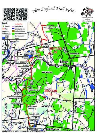
Map Legend
Icons on the map can be clicked to get directions on Google Maps (works best for Parking Icons).
Get the Map
This property is in NQTA Map #18. You can purchase NQTA Map Sets in our Shop.
Directions
1) Lake Wyola TH: Major DCR swimming, picnic and activities center. Parking for multiple cars.
See Section 5 for directions
2) Dirth Rd TH.: Half mile down Montague Rd at Net crossing. Parking for 8 cars
3) Wendell State Forest Headquarters TH. Paking for 12 cars
4) Diemand Farm Anchor Center and TH. On Mormon Hollow Rd. This is a major resupply food center and family activity center. Multiple parking area
5) Mormon Hollow TH: At crossing of Farley Rd and Mormon Hollow Rd. A intriguing and accessible picnic, brook and historical area. Parking for 4 cars
6) Farley Cliffs TH Located on Holmes Rd directly of 2A in Erving. This TH is the home of Farley Cliffs a major rock climbing area. Parking for 6 cars
7) Mountain Rd TH: Located ? miles from Mountain Rd and 2A. While Crag Mt is not open for access this is the last trail head on Section 16.
The trail leaves Mountain Rd TH a short road walk and re – enters brush and comes out at S.Mountain Rd with a present 3.2 mile road walk to Brush Mt TH and beginning of Section 16
Overview
Chapter 6 NET Sections 15 / 16
Wendell Forest/ Mormon Hollow/ Farley Cliffs
This corridor of the Q+M Experience is the NET (New England Trail) Sections 15 and 16.
The NET is managed by the Appalachian Mountain Club (AMC) and please respect all protocols and guidelines while on the NET trail section please go to outdoors.org for more information.
Photo Gallery
Activities
HikingAdditional Information
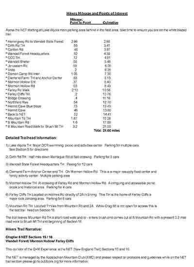
Hikers Mileage and Points of Interest
Mileage:
Point to Point Culmative
Acess the NET starting at Lake Wyola main parking area behind in the field area, take time to ensure you are on the white blazed trail.
* Hemingway Rd to Wendell State Forest. 2.86 2.86
* Dirth Rd TH. .55 3.41
* Carlton Rd. .46 3.87
* Wendell Forest Headquarters .52 4.39
* CCC TH. .12 4.91
* Wendell Sheter .55 5.46
* Jerusalem Rd. .59 6.05
* Vista .2 6.25
* Damon Camp Rd Inter. 1.05 7.30
* Diemand Farm TH and Anchor Center .83 8.13
* Mormon Hollow Ent. .37 8.40
* Mormon Hollow Rd. .03 8.43
* Farley Rd Walk 2.13 10.56
* Farley Cliffs TH. .2 10.76
* Bridge Crossing .4 11.16
* Northfield Res. .54 12.70
* Hermit Cave Blue blaze .73 13.43
* Hermit Cave .46 13.89
* Back to NET .52 14.41
* Mountain Td TH 1.87 16.28
* S Mountain Rd. 1.6 17.88
* S Mountain Road Walk to Brush Mt TH 3.2 21.00
Total 21.00 miles


