Newton Reservoir Pipeline Trails
Location
Map Legend

Icons on the map can be clicked to get directions on Google Maps (works best for Parking Icons).
Get the Map
This property is in NQTA Map #3. You can purchase NQTA Map Sets in our Shop.
Directions
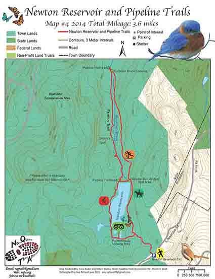
Newton Reservoir/Pipeline Trail- from the Newton Reservoir Gate follows the trail to a ‘Y’ in the road. The left hand side follows the back side of the Reservoir. The right side of the ‘Y’ follows the front of the reservoir. Follow either trail to the Buckman Brook Crossing. The trail then follows the yellow “P” of the Pipeline Trail along the Buckman Brook. Along the way, there are several outstanding vistas providing different view points of this popular water body. Please be respectful of private property and stay on the marked trail.
Overview
Newton Reservoir/Pipeline Trail- from the Newton Reservoir Gate follows the trail to a ‘Y’ in the road. The left hand side follows the back side of the Reservoir. The right side of the ‘Y’ follows the front of the reservoir. Follow either trail to the Buckman Brook Crossing. The trail then follows the yellow “P” of the Pipeline Trail along the Buckman Brook. Along the way, there are several outstanding vistas providing different view points of this popular water body. Please be respectful of private property and stay on the marked trail.
Photo Gallery
Activities
Biking, Cross-country skiing, Equestrian, Hiking, Naturalists, SnowshoeingAdditional Information
North Quabbin Trails Association would like to thank the following for their continued support: various private land owners, Athol Conservation Commission and The Trustees of Reservations. NQTA would also like to thank all volunteers who helped to make this new trail system a reality.