Poplar Mountain Cliff Ridge Trail
Location
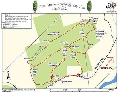
Map Legend

Icons on the map can be clicked to get directions on Google Maps (works best for Parking Icons).
Get the Map
This property is in NQTA Map #14. You can purchase NQTA Map Sets in our Shop.
Directions
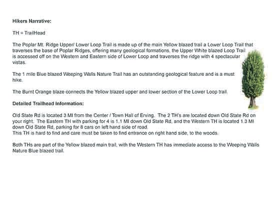
Old State Rd is located 3 miles from the Center / Town Hall of Erving. The 2 TH’s are located down Old State Rd on your right. The Eastern TH with parking for 4 is 1.1 miles down Old State Rd, and the Western TH is located 1.3 miles down Old State Rd, parking for 8 cars on left hand side of road.
This TH is hard to find and care must be taken to find entrance on right hand side, to the woods.
Both THs are part of the Yellow blazed main trail, with the Western TH has immediate access to the Weeping Walls Nature Blue blazed trail.
Overview
The Poplar Mt. Ridge Upper/ Lower Loop Trail is made up of the main Yellow blazed trail a Lower Loop Trail that traverses the base of Poplar Ridges, offering many geological formations, the Upper White blazed Loop Trail is accessed off on the Western and Eastern side of Lower Loop and traverses the ridge with 4 spectacular vistas.
The 1 mile Blue blazed Weeping Walls Nature Trail has an outstanding geological feature and is a must hike.
The Burnt Orange blaze connects the Yellow blazed upper and lower section of the Lower Loop trail.
Photo Gallery