QM Country Road Walk
Location
Map Legend

Icons on the map can be clicked to get directions on Google Maps (works best for Parking Icons).
Get the Map
This property is in NQTA Map #20. You can purchase NQTA Map Sets in our Shop.
Directions
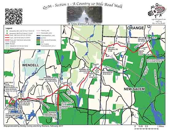
Gate 29 in New Salem, of the Quabbin Reservoir in New Salem on RTE 202.
Lake Wyola Parking Area Shutesbury
Lake Rd off Dennison Rd is the main parking, beach and recreational area.
Overview
Mileage:
Point to Point / Culmative
Starting at Gate 29 in New Salem, exiting the Quabbin Reservoir in New Salem on RTE 202, the trail crosses this busy road, please take care. Follow the road walk thats listed here.
* Elm St. .8 .8
* Bear’s Den 1.0 1.8
(**See description below)
* Neilson Rd 2.1 2.9
* Wendell Rd 1.1 4.0
* Jennison Rd / 6.0 6.0
Rockwell Hill Rd (NET / QM Intersection)
* Lake Wyola 4.0 10.0
(*** See description below)
From crossing of NET at Jennison / Rockwell Hill is an optional 1 mile hike on NET south along West branch of Swift River to stunning water lookout vista.
** THE BEAR’S DEN IS MANAGED BY THE TRUSTEES AND IS A WONDERFUL 6 ACRE PICNICKING AND WATER VIEWING AREA. A CAN’T MISS FOR THIS ROAD WALK. **
*** LAKE WYOLA IS A MAJOR DCR PICNICKING, RECREATIONAL AND SWIMMING AREA. PLEASE GO TAKE A DIP ON A HOT SUMMER DAY. **
Photo Gallery