Q+M Stratton / Mount Grace / Warwick Forest
Location
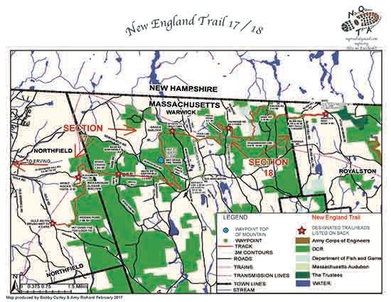
Map Legend

Icons on the map can be clicked to get directions on Google Maps (works best for Parking Icons).
Get the Map
This property is in NQTA Map #19. You can purchase NQTA Map Sets in our Shop.
Directions
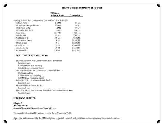
1) Gulf Rd / Brush Mnt Conservation Area – Northfield
Parking 4 cars
4.5 Miles from RTE 2 Erving
2.06 MI from Northfield Center
2) Alexnder Hill Rd TH – 2 miles on Alexander Rd to TH
Multi car parking
6.56 MI from RTE 2 Erving
1.22 MI from Northfield Center
3) Bass Rd TH – 1.2 miles on Bass Rd to TH
Parking 4 cars
4) Northfield Rd / White Rd TH
Parking 3 cars
5) RTE 78 TH – 1.2 miles North from Mnt. Grace Conservation Area
Parking 6 cars
Overview
Chapter 7
NET Sections 17/18
Stratton Mountain / Mount Grace / Warwick Fores
This corridor of the Q+M Experience is along the NET sections 17/18.
Again this trail is managed by the AMC and please respect all protocols and guidelines, go to outdoors.org for more information.
Photo Gallery
Activities
HikingAdditional Information
Hikers Mileage and Points of Interest
Mileage:
Point to Point Culmative
Starting at Brush Hill Conservation Area on Gulf Rd in Northfield
Hidden Pond 2.1 MI 2.1 MI
Richardson / Zlogar Shelter 2.4 MI 4.5 MI
Spirit Rock Vista .4 MI 4.9 MI
Alexander Hill Rd TH .5 MI 5.4 MI
Road Cross 1.53 MI 6.93 MI
Bass Rd TH .52 MI 7.45 MI
Northfield TH 2.3 MI 9.68 MI
Little Mount Grace .8 MI 10.48 MI
Mount Grace 1.8 MI 12.28 MI
RTE 78 TH 1.6 MI 13.88 MI
Winchester Rd .7 MI 14.58 MI
Richmond Rd 2.5 MI 17.08 MI