Tully River Basin Trail
Location
Map Legend

Icons on the map can be clicked to get directions on Google Maps (works best for Parking Icons).
Get the Map
This property is in NQTA Map #11. You can purchase NQTA Map Sets in our Shop.
Directions
From the junction of MA 32 and MA 2A at Starrett’s Tool Company in Athol, follow MA 32 north for 3.2 miles to the Tully Lake Recreation Area entrance. To reach the campground, Long Pond, and Doane’s Falls, continue north on MA 32 for 0.5 miles, then turn right on Doane Hill Road.
After 0.3 miles, bear right at the intersection with Stewart Road and continue 0.5 miles to the campground and Long Pond boat launch, 0.6 miles to the lower Doane’s Falls parking area, or 0.9 miles to the Doane’s Falls Reservation main entrance.
Overview
The watershed of the Tully River, a major tributary of the Millers River, is a largely undeveloped area of rocky hills, forests, and wetlands. The river is comprised of two main stems: the East Branch, which originates in southern New Hampshire and serves as the source of Long Pond and Tully Lake in Royalston, and the West Branch, which winds through the hilly western portion of the valley in Warwick, Royalston, and Orange. The branches converge at the Athol-Orange town line near Little Tully Mountain and Sportsman’s Pond, then the main stem discharges into the Millers River a short distance downstream at Cass Meadow and Rich Park in Athol.
The Tully Trail, marked with yellow blazes and trail signs, is a 22-mile circuit that passes many natural features of the Tully River Valley, including Royalston Falls, Long Pond, Jacob’s Hill and Spirit Falls, Tully Lake, Tully Mountain, and the Orange and Warwick State Forests. The trail coincides with the New England Trail (NET) from Bliss Hill Road in Royalston to Falls Brook at Royalston Falls Reservation. Camping is available at the Tully Lake Campground (seasonal) and a shelter at Falls Brook. The route detailed here follows the eastern portion of the Tully Trail from Royalston Falls Reservation to Tully Lake and Doane’s Falls.
Tully Campground and Recreation Area.
See more information about the full Tully Trail at The Trustees website.
A variety of facilities and recreational activities are available for visitors here. The Tully Lake Recreation Area, located on the west shores and managed by the Army Corps of Engineers, includes a boat launch, picnic area, playground, access to a universally-accessible segment of the Tully Trail, and a disc golf course in the woods surrounding Tully Lake Dam. Tully Lake Campground, operated by The Trustees, includes 35 tent sites on the north shores of the lake. Other facilities include showers, restrooms, a volleyball court, canoe and kayak rentals, and easy access to hiking trails, two boat launches, and the Mountain Bike Trail. The campground is open weekends from early May to late October, and weekdays from the end of May to mid-September (parking is available year-round for day use).
See more about the campground at The Trustees website.
Tully River Basin Trail Map
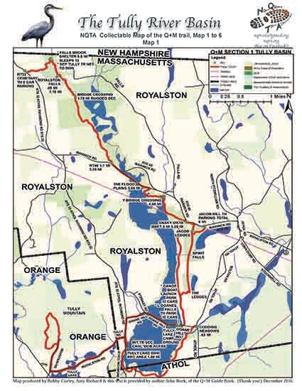
Click map for larger view